The Gulf of Nicoya: Wildlife, Geography and Boat Routes
Every Isla Tortuga tour is really a crossing of the Gulf of Nicoya. Knowing what that body of water is, which islands sit in it and when the wildlife moves through changes what you see from the deck.
Booking Choice: An island lunch, snorkeling equipment and a Negritos wildlife stop. Explore Puntarenas Island Day: Shared Or Private
Start: Puntarenas. Confirm age rules and extras before booking.
Crossing the gulf: road time versus water time
Road and water times are taken from the published itineraries of the six Isla Tortuga tours on this site; the Puntarenas figure is given as a range because vessel type changes it.
What exactly is the Gulf of Nicoya?
The Gulf of Nicoya is a large Pacific inlet on Costa Rica's northwest coast, lying between the mainland and the Nicoya Peninsula. It runs roughly northwest to southeast, is fed by rivers including the Tempisque, and is one of the most productive estuarine systems on the Pacific side of Central America. Isla Tortuga sits inside it.
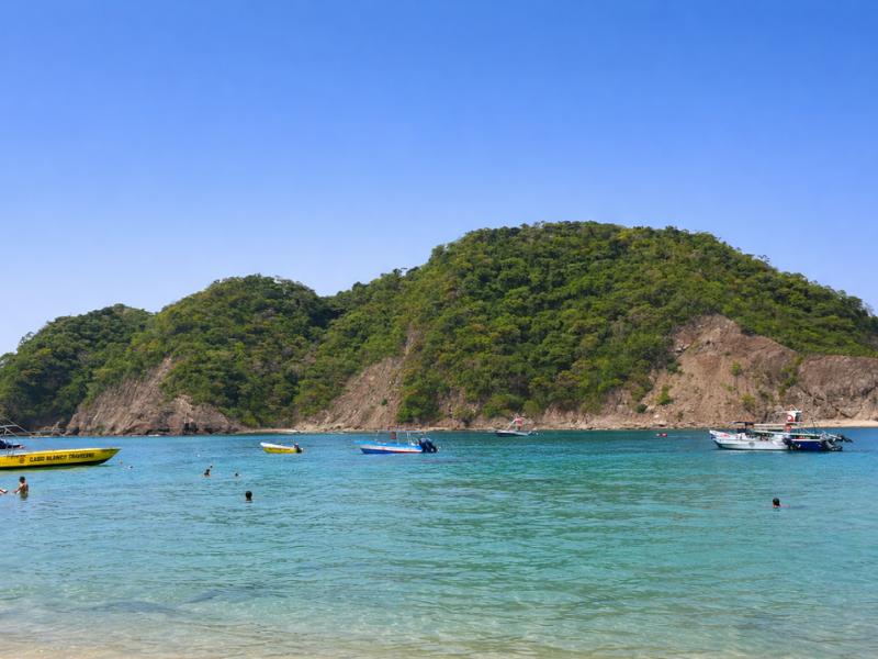
Picture the shape first, because it explains almost everything else. The Nicoya Peninsula hangs off the northwest of Costa Rica like a thumb, and the gulf is the water trapped between that thumb and the palm of the mainland. It opens to the Pacific at its southern end and narrows to a shallow, muddy estuary at its northern head. That geometry is why the crossing to Isla Tortuga feels like protected water rather than open ocean: for most of the route you have land on both sides.
The gulf is conventionally split into two parts. The upper or inner gulf is shallow, turbid and strongly influenced by river outflow, particularly from the Tempisque. The lower or outer gulf is deeper, clearer and more marine in character, and this is the half that matters to visitors, because Isla Tortuga, the Negritos group and the main tour routes all sit in it. The transition between the two is roughly where Puntarenas sits on its long sandspit.
For the wider geographic framing, the Gulf of Nicoya and Nicoya Peninsula entries lay out the boundaries and the surrounding provinces. What those pages do not tell you is how the water behaves on a Tuesday morning in February, which is what the rest of this guide is about.
| Feature | Detail | Why it matters on a tour |
|---|---|---|
| Type of water body | Large Pacific inlet and estuary system | Sheltered compared with open coast, but not flat calm |
| Orientation | Runs broadly northwest to southeast, open to the Pacific in the south | Swell enters from the south, which is why the outer gulf is livelier |
| Two halves | Shallow turbid upper gulf, deeper clearer lower gulf | All Isla Tortuga routes work the lower gulf, where visibility is better |
| Main river input | Tempisque and other rivers draining into the upper gulf | Sediment and nutrients, which drive the productivity and the fishing |
| Main port | Puntarenas, on a long sandspit | The principal mainland departure point and ferry terminal |
| Opposite shore | Southeastern Nicoya Peninsula: Paquera, Tambor, Montezuma | The shortest crossings to Isla Tortuga start here |
Which islands sit in the gulf, and which do tours actually visit?
The gulf holds a scatter of islands, from inhabited Isla Chira down to bare rocks. Tour boats to Isla Tortuga interact with only a handful: the Tortuga pair themselves, the Negritos group where the spider monkey stop happens, and Isla San Lucas, which most Puntarenas routes pass rather than land on.
The islands are not a chain in any tidy sense. They are scattered through the lower and middle gulf, some close to the peninsula shore, some sitting out in open water. A few are inhabited and have fishing communities. Most are uninhabited, and several carry formal protection that rules out landing at all.
For a visitor, the useful distinction is between islands you can set foot on and islands you look at from a boat. Isla Tortuga is the first category, and it is close to the only one on a standard day tour. The Negritos islands are the second: boats slow along the shoreline while guides scan the canopy, but nobody lands, because the reserve does not allow it.
| Island or group | What it is | Status on a Tortuga tour |
|---|---|---|
| Isla Tortuga, Alcatraz and Tolinga | Two small uninhabited islands with one visitor beach | The destination; boats land on the sand |
| Islas Negritos | Protected islets near the peninsula, forested | Slow pass for spider monkeys, roughly 25 minutes out from the Puntarenas side |
| Isla San Lucas | Former penal colony, now protected as a national park | A landmark on the Puntarenas route rather than a stop on these tours |
| Isla Chira | The largest island in the gulf, inhabited, fishing communities | Upper gulf; not on Isla Tortuga routes |
| Isla Venado and Isla Caballo | Inhabited islands with small fishing populations | Middle gulf; not on Isla Tortuga routes |
| Isla Guayabo and Isla Pajaros | Small protected islets, important seabird sites | Seen at distance; landing is not permitted |
The practical upshot is that a Tortuga day gives you one landing and one or two slow passes. Anyone hoping to island-hop across the gulf on a day tour is imagining a different product. The protection regime, not the operators, is what sets that limit.
Why is Isla Tortuga two islands, and what are Alcatraz and Tolinga?
What everyone calls Tortuga Island is a pair of uninhabited islands, Alcatraz and Tolinga, sitting side by side about 12 kilometres off the southeastern tip of the Nicoya Peninsula. Only one has the visitor beach. From the water they read as a single green mass with a white strip at the foot, which is why the singular name stuck.
The names rarely come up on the boat. Guides say Tortuga, passengers say Tortuga, and the distinction only surfaces if someone asks why the map shows two shapes. Approaching from the Puntarenas side, the second island reads as a headland rather than a separate landmass, and the channel between them is narrow enough to disappear at the angle most boats take.
Isla Tortuga and the Negritos islands are separate places in the Gulf of Nicoya. Some tours pass Negritos for wildlife viewing before visiting Tortuga. The excursions recommended here return the same day and do not include accommodation. Related reading: Sistema Nacional de Areas de Conservacion
That produces one visible consequence on the day: a cap on how many boats can land on the beach. In the dry season, when demand from San Jose, Jaco, Puntarenas and Montezuma converges on the same small stretch of sand, that cap is the reason a good operator books out days ahead. It is also the reason the beach at midday in high season, while busy, never reaches the density of a mainland resort strip.
What grows and lives on the islands themselves?
The vegetation is tropical dry forest, the coastal forest type that covers much of the Nicoya Peninsula and turns brown in the dry months before greening up with the first rains. Behind the beach the forest climbs quickly and stays mostly out of bounds to visitors. Iguanas sun themselves on the rocks at the edges of the sand, seabirds work the shoreline, and howler monkeys can be heard from the jungle edge on a quiet morning, which on an island this size carries a long way.
What is the Islas Negritos Biological Reserve protecting?
The reserve protects a set of small, uninhabited gulf islands and their surrounding waters: dry forest, seabird nesting colonies, and the reef systems around them. It exists because small islands are exactly where nesting seabirds and isolated animal populations are most vulnerable to development and introduced species.
Island reserves work differently from mainland national parks. There is no gate, no ranger station you queue at, no trail network. The protection is a boundary drawn on the water, and the enforcement mechanism is the licensing of boats. That is why the visitor experience is what it is: you arrive on an authorised vessel, you use one beach, and you leave the same day.
Seabirds are a large part of the reason. Small offshore islands with no ground predators are prime nesting habitat, and a colony that has bred on a rock for generations will abandon it if the rock is disturbed regularly. The same logic applies to the primate populations on the forested islets, which are small, isolated, and impossible to top up from the mainland.
For visitors this translates into a short list of behaviours that guides will reinforce: do not feed anything, do not take shells or coral, keep to the beach and marked paths, and do not stand on the reef while snorkelling. None of it is onerous, and all of it is the price of the island staying worth visiting.
| Protected element | What it covers | Practical effect on visitors |
|---|---|---|
| Island land surface | Tropical dry forest on the islets | No construction, no accommodation, no overnight stays |
| Seabird nesting sites | Colonies on small, predator-free islands | Landing prohibited on most islets; boats pass without stopping |
| Primate populations | Spider monkeys on the Negritos group | Viewing from the boat, no feeding, no landing |
| Surrounding reef | Shallow volcanic rock reef with coral patches | Snorkelling permitted, standing on the reef is not |
| Landing capacity | Number of authorised boats per day | Book ahead in dry season; walk-up spots are unreliable |
Where do the spider monkeys live, and what is Isla San Lucas?
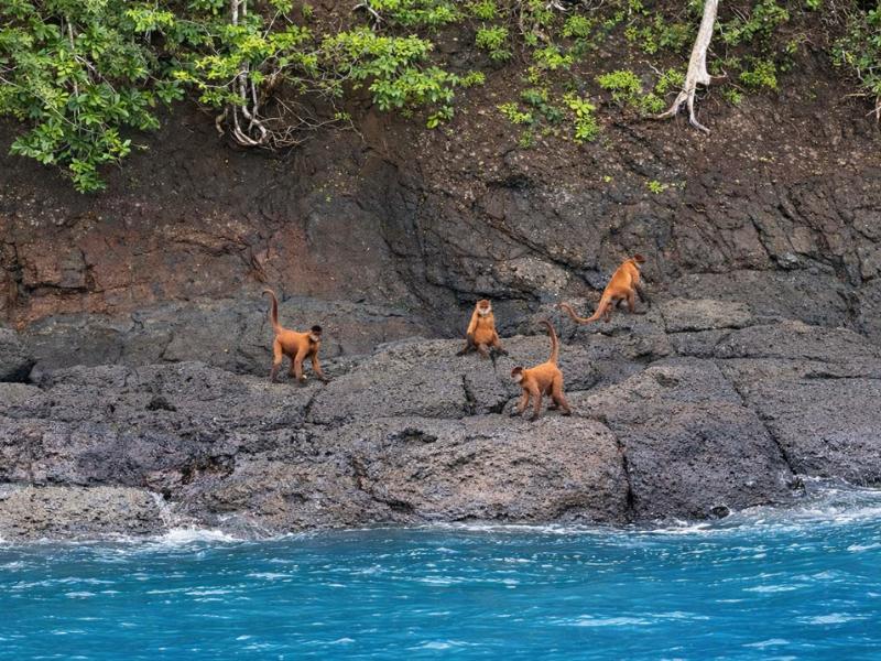
The spider monkey stop on Isla Tortuga tours happens at the Negritos islands, not on Tortuga itself. Boats from the Puntarenas side reach it about 25 minutes out and slow along the shoreline while guides scan the canopy. Isla San Lucas, a former penal colony now protected as a national park, is a separate island most Puntarenas routes pass in transit.
Getting this straight avoids a common disappointment. People book expecting monkeys on the beach where they land, and the beach at Isla Tortuga is not where the monkeys are. What you get instead is a deliberate slow pass at the Negritos group, built into the itinerary rather than treated as a bonus, where the guides look for the resident spider monkeys in the canopy. The private Puntarenas charter lists this stop at around 25 minutes. The Jaco tour builds in a visit to the Negritos wildlife area on the way through.
Sightings are likely rather than guaranteed. Spider monkeys are canopy animals, they move, and a boat passing a forested shoreline is working at the mercy of where the group happens to be feeding that morning. Guides who have run the route for years know the favoured trees, which is the practical difference between spotting them and not.
Isla San Lucas is a different kind of landmark. It served for decades as a prison island, one of the harshest in Central America, and after the penal colony closed the island passed into protection and is now a national park. Its ruined buildings are still there. Most standard Isla Tortuga tours do not land on it, so treat it as something you see on the water rather than an itinerary item. If a route passes close, the guides will usually point it out and tell the story, which is a better one than most islands can offer.
Curu is the third wildlife piece and the only one where you walk. The Curu Wildlife Refuge on the peninsula shore is where the evening bioluminescence departure begins, with an afternoon walk that routinely turns up howler monkeys, white-faced capuchins, white-tailed deer, coatis and iguanas before the boat leaves at five. From Curu the crossing to the island is only 15 minutes.
How do tides and sea state work here, and why are mornings calmer?
The gulf has a large semi-diurnal tide, with two highs and two lows a day and a range that regularly runs to a couple of metres. Sea state is driven less by tide than by the daytime sea breeze, which builds through the morning and peaks in the afternoon. That is why the outbound crossing is usually smoother than the return.
The daily pattern is consistent enough to plan around. Early morning is typically the calmest window: the land and sea have equalised overnight, the breeze has not yet built, and the water surface is at its flattest. As the land heats through the morning, air rises over it and draws sea air in behind, and that thermal breeze puts a chop on the water. By mid afternoon, when most tours are heading back, the gulf is usually livelier than it was at nine.
This is the mechanical reason behind advice you will see everywhere about booking the morning departure. It is not only about crowds, though the crowd argument is real, with boats converging between 11am and 2pm. It is also about the sea, the light, and the underwater visibility, all three of which are better in the first half of the day.
Tide affects the snorkel more than the crossing. A rising tide brings clearer outer-gulf water in over the reef; a falling tide can pull sediment out from the shallows. Neither is dramatic at Isla Tortuga, where the reef sits in genuinely shallow water close to shore, but it explains why two people who snorkelled the same site a week apart can describe visibility differently. Costa Rica's Instituto Meteorologico Nacional publishes the coastal and marine forecasts if you want to check conditions before a trip.
| Time of day | Typical sea state | Underwater visibility | Boat traffic on the island |
|---|---|---|---|
| 7am to 9am | Calmest window, breeze not yet built | Best of the day | Almost none; first boats arriving |
| 9am to 11am | Light chop developing | Still very good | Building |
| 11am to 2pm | Moderate chop from the sea breeze | Reduced as swimmers stir the shallows | Peak; boats from every departure point |
| 2pm to 4pm | Liveliest part of the day | Variable | Thinning as morning groups leave |
| After 4pm | Breeze easing, swell settling | Not usually snorkelled | Empty except evening departures |
What wildlife can you realistically see, and when?
Dolphins are the year-round headline and turn up on crossings often enough that crews scan for them as routine. Humpback whales pass through between July and November. Eagle rays, manta rays and sea turtles appear around the reef, and the reef fish are constant: parrotfish, angelfish, sergeant majors and moray eels.
Costa Rica's Pacific coast is unusual in receiving humpback whales from both hemispheres, which is why the sighting window is as long as it is. The gulf and the waters off the southern Nicoya Peninsula are on that migratory corridor, and the Santa Teresa and Montezuma route in particular runs through water where crews watch for them between July and November. The honest framing operators use is that a whale is a gift rather than a promise, and a good guide will say so before you board rather than after.
Dolphins are the more reliable encounter. They appear on crossings from multiple departure points, boats slow when a pod shows, and this is common enough that several tour descriptions list dolphin watching as a feature rather than a possibility. What they cannot do is schedule it.
Underwater, the reef around Isla Tortuga is the draw. It is a shallow volcanic rock reef with coral patches, in water clear enough on a good dry-season morning to see the bottom from the surface. Parrotfish, angelfish, sergeant majors, butterflyfish, moray eels tucked into crevices, the occasional eagle ray gliding through, and green sea turtles with some regularity. It is not a world-ranking dive site and honest operators do not sell it as one. For a shallow, easy, warm-water snorkel reached from a beach, it is very good.
| Species | Best window | Where you see it | Realistic odds |
|---|---|---|---|
| Bottlenose and spotted dolphins | Year-round | On the crossing, from the deck | Common; crews slow the boat when a pod appears |
| Humpback whales | July to November | Outer gulf, notably the Montezuma and Santa Teresa route | Genuinely possible, never guaranteed |
| Eagle rays and manta rays | Year-round, better in clear water | Around the reef and on the crossing | Occasional |
| Green sea turtles | Year-round | Reef and shallows off the beach | Regular but not every session |
| Reef fish: parrotfish, angelfish, sergeant majors | Year-round | Shallow reef, swimming distance from the sand | Certain |
| Moray eels | Year-round | Crevices in the volcanic rock | Common if a guide points them out |
| Spider monkeys | Year-round | Negritos islands, from the boat | Likely on tours that build the stop in |
| Seabirds | Year-round | Islets and the shoreline throughout the gulf | Certain |
| Bioluminescent plankton | Year-round, best on dark nights | Night swim on the Curu evening departure | Depends on moon phase and water conditions |
Why is the gulf so productive, and what does that mean for the reef?
River input from the upper gulf, mangrove systems along its shores and seasonal upwelling combine to put a lot of nutrients into the water. That feeds a large fishery, supports the seabird colonies, and is a substantial part of why marine life around Isla Tortuga is as busy as it is.
Estuaries are among the most biologically productive environments anywhere, and the Gulf of Nicoya is a large one. Fresh water arriving from the Tempisque and other rivers carries sediment and nutrients into the upper gulf. Mangroves along the shoreline act as nurseries for juvenile fish and shellfish. The result is a food web with a very wide base, which is what supports everything visible from a boat: the fish on the reef, the birds working the surface, the dolphins that follow the bait.
There is a trade-off, and it is the reason your snorkel happens where it does. The nutrient-rich, sediment-laden water of the upper gulf is not clear water. Visibility improves as you move south and out towards the mouth, which is exactly where Isla Tortuga sits. The island gets the benefit of a productive system while sitting far enough out into the clearer lower gulf to have water you can actually see through.
Seasonality plays into this too. In the dry months from December to April, with little rain and therefore little river runoff, the water clears noticeably and visibility around the reef is at its best. In the wettest months, runoff and stirred sediment can cut it after heavy rain, though the effect passes within a day or two.
Who else uses this water: fishing fleets, ferries and ports?
The gulf is a working seaway, not just a tourist route. Puntarenas is a long-established port and ferry terminal, vehicle ferries run daily between Puntarenas and Paquera, artisanal fishing boats work the whole gulf, and island communities depend on boat traffic for everything. Your tour boat shares the water with all of it.
Puntarenas is the pivot. The city sits on a narrow sandspit reaching out into the gulf, which is why it developed as a port in the first place, and the Puntarenas entry covers that history. Today it handles the ferry link to the Nicoya Peninsula, a fishing fleet, cruise-ship calls, and the departure of most Isla Tortuga tour boats from the mainland side.
The Puntarenas to Paquera vehicle ferry is the piece most independent travellers meet. It is how cars and people cross to the southern peninsula without the long drive around the head of the gulf, and it is why Montezuma, Tambor and Santa Teresa are practical bases at all. If you are staying on the peninsula and taking a Tortuga tour from that side, the ferry is probably how you got there.
Artisanal fishing is everywhere and it is not decorative. Small boats work the gulf commercially, island communities like those on Chira and Venado are built around it, and the bioluminescence operator on the Curu side describes itself as family-run since 2000 with a stated commitment to conservation and responsible fishing. Understanding that the gulf is somebody's workplace tends to change how a visitor reads the small boats they pass.
| User of the gulf | What they are doing | Where you notice them |
|---|---|---|
| Vehicle ferries | Puntarenas to Paquera crossings, several times daily | Crossing your route in the middle gulf |
| Artisanal fishing boats | Small-scale commercial fishing, gulf-wide | Anchored or working in the shallows, everywhere |
| Tour and charter boats | Day trips to Isla Tortuga and the reserves | Converging on the island between 11am and 2pm |
| Port and cruise traffic | Puntarenas port operations and cruise calls | The Puntarenas waterfront on departure |
| Island communities | Chira, Venado and Caballo residents moving by boat | Middle and upper gulf, off the Tortuga routes |
How do the main boat routes actually cross the gulf?
Routes fall into two families. Mainland departures from Puntarenas and Jaco cross the open water of the lower gulf, taking 60 to 90 minutes. Peninsula departures from Montezuma, Tambor and Curu run along the sheltered coastline and reach the island in 15 to 45 minutes. The San Jose tour is a peninsula-free road trip bolted onto a Puntarenas crossing.
Working through them individually explains why the same island produces such different days.
The Puntarenas routes leave from the mainland side and head roughly southwest across the lower gulf. The speedboat departure uses a private dock in the Las Playitas neighbourhood; the private charter leaves at 8:30am from Guima Frost marina. Both cross open gulf water, both pass the Negritos group, and the private charter builds in a 25-minute stop there for spider monkeys before continuing to the island.
The Jaco and Herradura route is the longest of the mainland crossings, around 90 minutes, and it approaches the island from further south. It is also the route with the most added on land, because it starts with the Tarcoles River bridge crocodile stop before boarding, and includes a Negritos visit on the water.
The peninsula routes are the geographic winners. Montezuma to Isla Tortuga is 45 minutes along a coastline of jungle, cliffs and small beaches, and the Santa Teresa departure adds a road transfer to reach Montezuma first. Curu is closer still at 15 minutes, which is what makes an evening departure and a night return practical there and nowhere else.
The San Jose full-day tour is the outlier and the most-booked option on this site. It is a road trip of roughly two hours each way to the coast, wrapped around a gulf crossing of around 45 minutes and a full afternoon on the sand. The listed 18 hours is door to door, not time on the water, and knowing the difference is the single most useful thing to understand before booking it.
| Route | Water crossing | Gulf conditions on that leg | What you pass |
|---|---|---|---|
| Puntarenas, Las Playitas dock | 60 to 90 minutes | Open lower gulf; breeze builds by afternoon | Negritos group, San Lucas at distance |
| Puntarenas, Guima Frost, private | 60 to 90 minutes with a 25-minute Negritos stop | Same water, more flexible schedule | Negritos monkeys, stone arch on arrival |
| Jaco and Herradura | About 90 minutes | Longest mainland crossing, more exposed | Tarcoles crocodiles by road, then Negritos |
| Santa Teresa via Montezuma | 45 minutes | Sheltered coastal run along the peninsula | Peninsula coastline, whale corridor July to November |
| Curu Wildlife Refuge | 15 minutes | Shortest hop in the gulf | Refuge wildlife on foot, then sunset and night water |
| San Jose | About 45 minutes, after roughly 2 hours by road | Standard Puntarenas-side crossing | Central Valley scenery, then the gulf |
How does the gulf change through the year?
December to April is the dry season: calmest water, clearest visibility, most reliable departures and peak demand. May to June and September to October trade some weather certainty for lower prices and a far quieter island. Humpbacks pass between July and November, which cuts across the wettest stretch.
The seasonal split on this coast is sharp. In the dry months the tropical dry forest on the peninsula turns brown, rain is scarce, river runoff drops, and the gulf settles into the flat, clear condition that produces the photographs. March is the month most often singled out on this coast for that combination of flat water and strong visibility.
The green season is not the write-off some visitors assume. Rain on this coast tends to arrive as afternoon showers rather than all-day weather, mornings are frequently clear, and tours run through it. What changes is reliability: more chance of a choppy return, occasional cancellations after heavy weather, and more sediment in the water for a day or two after serious rain. In exchange, availability improves, prices soften and the beach is genuinely quiet.
The overlap that catches people out is the whale window against the rain. Humpbacks are around from July to November, and the wettest months sit inside that. If whales are the priority, accept some weather. If flat turquoise water is the priority, come in the dry season and treat a dolphin sighting as the marine highlight. The Costa Rica Tourism Board publishes regional seasonal guidance if you want to cross-check against the rest of your itinerary.
| Period | Sea state | Visibility | Wildlife | Crowding and price |
|---|---|---|---|---|
| December to February | Calmest of the year | Very good | Dolphins, rays, turtles | Peak demand, book ahead |
| March to April | Calm, warmest water | Best of the year | Dolphins, rays, turtles | Peak, with Easter a hard spike |
| May to June | Mostly settled, afternoon showers begin | Good, dipping after rain | Dolphins, rays | Better availability, lower prices |
| July to August | Variable, more chop | Moderate | Humpbacks begin, dolphins | Mid-year travel bump |
| September to October | Wettest stretch, occasional cancellations | Most variable | Humpbacks, dolphins | Quietest island of the year |
| November | Settling as the dry season approaches | Improving week by week | Late humpbacks, dolphins | Good value before the December rush |
What should you take away before you cross it?
The gulf is a sheltered, working, biologically busy stretch of water with a daily rhythm you can plan around. Cross it in the morning, from the closest practical departure point, in the dry season if visibility matters most and between July and November if whales do. The island is the destination; the gulf is most of the experience.
Three practical conclusions fall out of everything above. First, departure point is the biggest lever you control, because it determines whether you spend 15 minutes or 90 on the water and whether you are on sheltered coastline or open gulf. Second, time of day is the second biggest lever, because the same route at nine in the morning and at two in the afternoon is a different crossing. Third, season sets the ceiling on visibility and the odds on whales, and those two pull in opposite directions.
What nobody can control is the wildlife. Dolphins are likely, whales are seasonal and genuinely uncertain, spider monkeys depend on where the group is feeding, and turtles turn up when they turn up. Operators who promise otherwise are selling something they cannot deliver. The gulf is generous enough that most days produce something, and the honest version of the pitch is that the crossing itself, past protected islets in warm, sheltered, busy water, is worth the ticket even on a quiet wildlife day.